Photo by Neal Bolton
In the past four articles we’ve talked about several key aspects of landfill airspace. Now we’ll wrap that all up by talking about how to track and manage your airspace.
There are two reasons for tracking your airspace. The first is obvious; airspace is your most valuable commodity, and it generates revenue. Good business practices demand that you know how much you have and at what rate it is being consumed.
The second is equally important but often overlooked by administrative folks. Airspace is the yardstick you use to measure the efficiency and effectiveness of your operation, as you tweak your landfill practices looking for ways to optimize waste compaction.
Let’s start by defining some ways that airspace is measured.
Ultimate remaining capacity
If we combined your current lined capacity and the capacity of all future expansions, we’d have your total remaining capacity. That information is critical for your long-range planning, setting disposal tipping fees, planning future expansions, developing disposal agreements with your customers and making various financial projections.
Many landfill managers hire an engineer to calculate their total remaining capacity. That calculation is usually a pretty simple CAD process of comparing base grades to final grades and letting the computer spit out a volume. The final number includes landfill airspace that may be consumed by cover soil and construction materials. This takes some thinking but, in the end, it is a very logical, numbers-based analysis.
The other side of that coin is where you can apply your experience to pull the right operational levers that will reduce that consumption rate by achieving a higher compaction rate, reducing soil use and creating a filling sequence that maximizes passive settlement.
This entire process comes down to your ability to understand and affect one important translation. Your remaining airspace is measured in volume, typically cubic yards (in the U.S.) or cubic meters everywhere else. But when you translate the remaining capacity to revenue dollars, the units change to tons or kilograms.
For those of you who think in terms of math equations, your volume is fixed, but the density that converts volume to mass is a variable, one that you control based on how you operate. Thus, it follows that if you can stuff more tons into your remaining volume, you’ll make more money.
Measuring airspace

To measure landfill airspace, you must compare two topographic surfaces. Essentially, you’re looking at before and after. In modern times, it’s a given that those two surfaces will be digital and that you can have a CAD program perform the calculations. Yes, there may be some manual cleanup required to make sure the digital surfaces accurately represent the actual surfaces. This may require some adjustment to correct for heavy vegetation or temporary stockpiles of soil, green waste or other materials. But once the surfaces are accurate, volume calculation is a straightforward process.
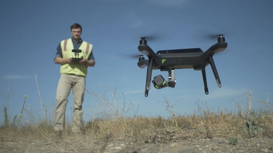
Measuring airspace has become much easier in recent years using drones for aerial mapping. Most surveyors, and an increasing number of landfill operators, have begun using drones to map the landfill surface. The process is so simple that we now see many landfills mapping their landfill monthly or quarterly instead of the annual mapping that’s previously been the industry norm.
Other techniques such as traditional aerial photogrammetry, ground-based surveys and even vehicle-mounted GPS units can be used, but unless you’re the type of person who still prefers a typewriter to a laptop, chances are you’ll be doing this work with a drone.
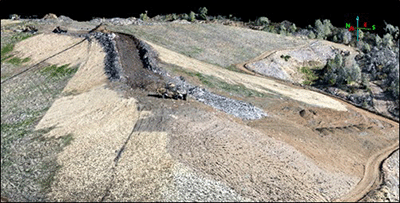
If you are a hands-on kind of manager, you’ll really enjoy receiving your digital map in the form of a 3D point cloud. This is a three-dimensional photograph where every pixel has an X, Y and Z value. When viewed through the right kind of computer software, those pixels become a 3D image that allows you to pan, zoom and rotate. And because it is a digital map of your landfill, you can read the coordinates and elevations as you move your cursor across the image. Here’s a look at a 3D point cloud created from a drone mapping project. You can see the active fill area, and even a landfill compactor in the center of the photo.
Annual updates
Typically, landfills will do a comprehensive update of their airspace consumption annually. In most cases, once a year strikes a good balance between the cost of doing the analysis and keeping your finger on the pulse of airspace consumption.
This annual airspace consumption report is often referred to as an AUF report, where AUF stands for airspace utilization factor. Aside from your financial reports, which are broadly based on airspace consumption data, the AUF is your most important metric because it measures the overall effective density of your landfill.
The basic AUF calculation is a simple equation of mass divided by volume. It is most commonly expressed in pounds per cubic yard (pcy). Alternatively, AUF may be measured in tons per cubic yard (tcy). If you’re outside the U.S., you’ll be measuring in kg per cubic meter (kg/m3). We’ll run through an example.
A landfill hires an engineer to fly the site with a drone and develop a digital surface. That current surface is compared with last year’s surface and, after some analysis, the engineer determines that 345,400 cubic yards of landfill airspace have been consumed. During the period between those two surfaces, scale records indicate the landfill received 203,875 tons of waste. Based on those two simple numbers, we can calculate that the landfill achieved an AUF of 0.59 tons per cubic yard per this equation (See Below).
AUF = 203,875 tons/345,400 cy = 0.590 tons/cy = 0.59 tcy
This can also be expressed as 1,180 pounds per cubic yard using the same equation with a conversion factor (See Below).
AUF = (203,875 tons/345,400 cy) x (2000 pounds/1 ton) = 1,180 pcy
We’ve done a number of national surveys, asking landfill managers, “What is the most important thing at your landfill?” The answer is airspace. So, it’s no surprise that when we ask them to list their most important metric, they overwhelmingly agree that it is their airspace utilization factor or AUF.
As the late Peter Drucker said, “You can’t manage what you don’t measure.” In that regard, no landfill manager can be effectively managing unless he or she is measuring their AUF.
You may be shocked to learn that many landfill organizations are not regularly measuring their AUF. In fact, many simply do not know their AUF. They are playing the big game of pushing, packing and covering the trash, but nobody is keeping score.
If you are currently tracking your AUF, or when you start tracking it—I’m assuming you will start—don’t be surprised to see that over time, your AUF shows a year-over-year increase. This is typical and a result of the underlying waste settling. This shows your overall AUF. But it’s also important to monitor your operational or year-to-year AUF.
To the extent possible, work with your engineer to isolate before/after fill calculation to the boundary of only what was filled during the most recent period. This will help avoid introducing topographic error into the calculation. It will also give you a more accurate estimate of your operational AUF, without introducing settlement from older, inactive areas. By focusing specifically on the most current fill area, you’ll be better able to see the effects of any operational improvements you make.
Remember, the remaining volume of your landfill may be fixed, but the number of tons it can hold is very dependent on how well you compact the trash and minimize soil usage. Over the years, we’ve often seen landfills increase their AUF by as much as 30 percent by following the guidelines set forth in the past four articles. Applying some effective AUF tracking can help you see those good trends.
Managing your landfill’s airspace is not rocket science, but it is science. You can do this.
Neal Bolton is President of Blue Ridge Services Montana Inc. He has been improving solid waste operations for more than 47 years. You can contact Neal at neal@blueridgeservices.com.
Latest from Waste Today
- Fleetio launches AI capability to accelerate fleet maintenance approvals
- Recycle Ann Arbor extends drop-off station operating hours
- Sybilion seeks to help manufacturers confidently address volatility
- Ecowaste Solutions partners with city of Trinity, Texas
- Bristal Hauling acquires G&R Garbage Disposal
- Baltimore trash collection expected to slow as WTE facility closes for maintenance
- Landfill Insights | Connecting the dots: Policy to practice
- FCC Environmental Services awarded collection contract in Florida